Seven stops on the Fourvière hill. Two thousand years of one civic-religious function performed first by Romans, then by Christians, then by a nineteenth-century basilica built atop the original Roman forum. Two and a third kilometres. The textbook specimen of an imperial provincial capital, read across the dynasties and across the religions, on a single hill above the Saône-Rhône confluence.
Start · Esplanade de Fourvière: The Topographic and Dynastic Frame
DirectionsStops
- 1

Esplanade de Fourvière: The Topographic and Dynastic Frame
Panoramic esplanade adjacent to the basilica at the summit of the Fourvière hill, the highest publicly accessible point on the hill and the original site of Lucius Munatius Plancus's forty-three BCE Roman foundation. The Roman provincial forum, the *forum vetus,* stood at this elevation. Views east-northeast to the Saône-Rhône confluence and across to the Croix-Rousse; views south-west to the Mont Pilat range from which the longest aqueduct descended.
- 2

Grand Théâtre Romain: The Dramatic-Performance Infrastructure
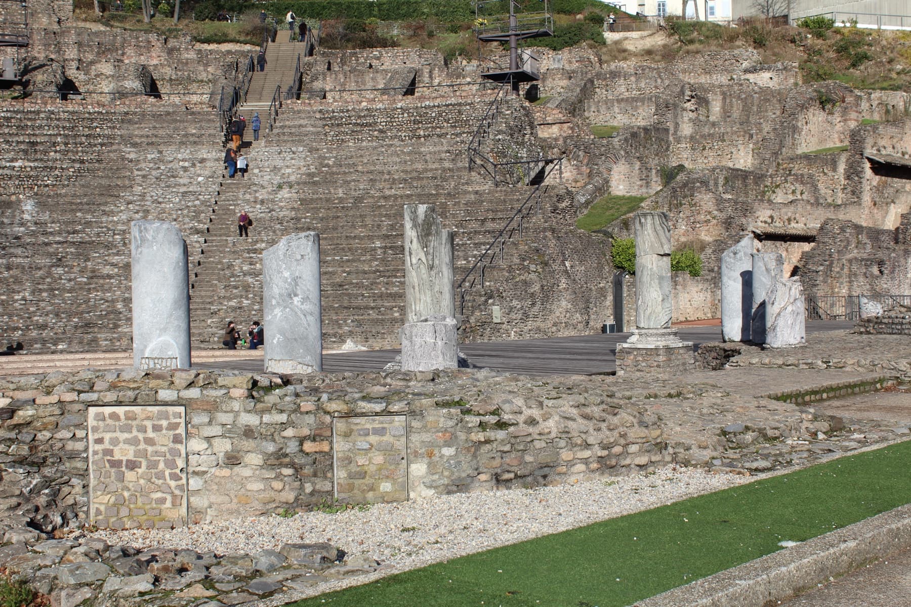
Roman theatre cut into the Fourvière hillside, begun ca. fifteen before the common era under Augustus, expanded under Hadrian in the second century to a final diameter of one hundred and eight metres and a capacity of about ten thousand seats. The largest of Lugdunum's two Roman theatres. Inscribed within UNESCO World Heritage listing eight hundred and seventy-two.
- 3

Odéon Romain: The Second-Theatre Proof of Provincial-Capital Status
Smaller Roman theatre built in the early to mid-second century CE, likely under Hadrian. Diameter seventy-three metres; capacity around three thousand seats. Roofed when built; used for poetry recitations, musical performances, and rhetorical contests. One of only two surviving Roman two-theatre pairs in Gaul, the other at Vienne.
- 4

Musée Lugdunum: The Documentary Anchor
Gallo-Roman museum designed by Bernard Zehrfuss between nineteen sixty-nine and nineteen seventy-five, inaugurated fifteenth of November nineteen seventy-five. Unsurfaced reinforced concrete, intentionally buried into the hillside; central spiral ramp inspired by the Guggenheim in New York. Houses the Claudian Tables and the Coligny calendar. Wikidata Q five zero nine.
- 5

Aqueduc du Gier Overlook: The Water-Engineering Pillar
Hillside terrace overlooking the south-west approach to Fourvière along which the four aqueducts of Lugdunum arrived. The longest, the Aqueduc du Gier, ran eighty-six kilometres from Mont Pilat. The best-preserved section at Chaponost retains seventy-two of the original ninety-two arches in opus reticulatum, a Roman hydraulic technique rarely found outside Italy.
- 6

Site Archéologique de Saint-Just: The Roman-to-Christian Transition
Archaeological garden preserving the foundations of a fourth-century Christian funerary basilica built directly atop a Gallo-Roman necropolis and on the foundations of a Roman mausoleum, possibly that of Justus of Lyon. Excavated nineteen seventy-one to nineteen seventy-four and nineteen seventy-eight to nineteen eighty.
- 7

Basilique Notre-Dame de Fourvière: The Closing Specimen
Nineteenth-century basilica built eighteen seventy-two to eighteen eighty-four by Pierre Bossan, completed after his death by Sainte-Marie Perrin, consecrated eighteen ninety-six. Romanesque-and-Byzantine hybrid; four towers each forty-eight metres high representing the four cardinal virtues. Sits atop the original Roman *forum vetus* that gave the hill its name. Wikidata Q one seven zero five eight six.
Details
Best Time to Visit
Morning to early afternoon on a weekday, ideally Tuesday through Friday. The hillside paths are quietest before ten and the light on the theatre cavea reads best in mid-morning, around nine to eleven, when the sun crosses the slope at an oblique angle and the stepped seating throws clean shadows. Avoid Sunday morning, when the basilica services bring large crowds onto the esplanade and the funicular up from Vieux Lyon runs at capacity. The Musée Lugdunum is closed Mondays and on the first of January, the first of May, and the twenty-fifth of December.
Pro Tips
- •The funicular from Vieux-Lyon station to Fourvière saves the steepest climb at the start of the walk and runs every ten minutes from early morning. A standard TCL ticket is valid; tap on entry. The funicular arrives directly at the esplanade where stop one begins.
- •The Musée Lugdunum at stop four is the documentary anchor of the entire tour. The audio reads the building from outside, but the Claudian Tables are visible only inside. Allow forty-five minutes for an interior visit if you want to see them; the museum is free for visitors under twenty-six and on the first Sunday of each month, otherwise around seven euros.
- •The Grand Théâtre at stop two and the Odeon at stop three are open to the public outside festival hours and entry is free. You can walk down into the cavea of the Grand Théâtre and stand on the orchestra floor; the audio anchors on the upper walkway, but the lower view is worth five extra minutes.
- •The aqueduct overlook at stop five reads the Aqueduc du Gier as a system from the hillside. The actual arches at Chaponost, fourteen kilometres south-west, are a separate half-day trip if you want to walk under them; the Plat de l'Air site is free and accessible by car or by the C ten bus from Lyon Perrache.
- •The Saint-Just archaeological garden at stop six is an open public space with no admission and is accessible at any reasonable hour. The interpretive panels at the perimeter are in French only; the audio carries the dating context the panels assume you already have.
- •Notre-Dame de Fourvière at stop seven is free to enter and the basilica interior is worth a brief walk through after the audio closes. The rooftop walkway above the basilica is accessible on guided visits booked in advance through fourviere.org; the rooftop is the best panoramic view of the city and a strong coda to the corridor.
- •The full walk including stop dwell runs about two hours. If you have only one and a half, end at the Saint-Just garden and pick up the basilica on a return visit; the thesis still resolves at stop six on the Roman-to-Christian transition, with the closing-specimen capstone deferred.
Safety & Precautions
- •The Fourvière hill is steep and the paths between the basilica esplanade and the Saint-Just garden include several flights of stone steps. Wear closed shoes with grip; the stones are uneven and the descent from stop four to stop six loses about ninety metres of elevation across roughly five hundred metres of path.
- •The Roman theatres at stops two and three have no perimeter railings on the upper cavea. Keep children within arm's reach and stay on the marked walkways; the stone seating is worn smooth in places and can be slippery in wet weather.
- •The Musée Lugdunum is closed Mondays. If you walk on a Monday, the building exterior is fully visible from the path and the audio still resolves outside, but the interior collections and the Claudian Tables are not accessible.
- •Lyon summers run hot and the Fourvière hillside has limited shade between the basilica esplanade and the museum. Carry water and consider an early-morning or late-afternoon start in July and August. The basilica interior and the Musée Lugdunum are both air-conditioned and serve as cool-down points.
- •Pickpocketing is documented around the basilica esplanade, particularly on summer weekends when tour-bus arrivals concentrate visitors at the panoramic viewpoint. Keep wallets and phones in front pockets or zipped bags while reading the introductory transcript on the esplanade.
- •The funicular from Vieux-Lyon back down to the river runs until around ten in the evening; the last departure is posted at the upper station. If you finish the tour after dark, the Montée Nicolas de Lange staircase descent is steep and poorly lit, and the funicular is the safer route.
Travel advisory: Exercise Increased Caution (Level 2).
Gallery
Related Reading
Go deeper on what you'll see, hear, and walk through.
Overview
Best Self-Guided Walking Tours in Lyon (2026)
4 min
Overview
Lyon Travel Guide: How Many Days, Getting Around, When to Go (2026)
5 min
Overview
One Day in Lyon: A Walkable Riverside Itinerary (2026)
5 min
Thematic
Best History Walking Tours in Lyon (2026)
3 min
Thematic
The City Silk Built: How One Fabric Made Three Different Lyons
4 min
Companion
Fourvière and Lugdunum: How to Read the Capital of Roman Gaul on One Hill
4 min
Read the walk
The full story of Lugdunum: The Capital of Roman Gaul, in words. Prefer to listen? Play it narrated, from home or on location.
Introduction
Two thousand and sixty-eight years ago, a Roman senator named Lucius Munatius Plancus founded a colony on the hill above the Saône-Rhône confluence. He called it Colonia Copia Felix Munatia. By the end of the first century, everyone called it Lugdunum. The name of the hill comes from Latin. Forum vetus. The old forum.
Lyon is the most architecturally legible Roman city in France because Lugdunum, founded by Munatius Plancus in forty-three before the common era on the Fourvière hill, was the capital of Roman Gaul, and what is still standing reads like a textbook specimen of an imperial provincial capital. Grand Theatre, Odeon, Three Gauls Sanctuary remnants, aqueduct fragments.
Two Roman emperors were born on this hill. Claudius on the first of August in ten before the common era. Caracalla on the fourth of April in one hundred and eighty-eight. The imperial mint that struck the gold and silver coins of the western Roman provinces was established here by Augustus in fifteen before the common era. Four aqueducts brought water here, the longest of them eighty-six kilometres from Mont Pilat. On the nineteenth of February in one hundred and ninety-seven, on the plain below, Septimius Severus defeated Clodius Albinus in one of the largest and bloodiest battles in Roman history and let his soldiers burn the city for backing the wrong claimant. A functional bundle of administration, military, religion, commerce, and culture, read across the dynasties and the religions on one hill.
Seven stops, about four kilometres, one hundred and twenty minutes from the Esplanade de Fourvière down through the theatres and back. When you arrive at the Esplanade de Fourvière in front of the basilica, begin with stop one.
1. Esplanade de Fourvière: The Topographic and Dynastic Frame
Welcome to the Esplanade de Fourvière. Hold the panorama you have just been introduced to and read it now as a working map. Per the Lyon Tourist Office's UNESCO World Heritage record and the Wikipedia entry for the Fourvière hill, the slope you are standing on rises one hundred and thirty metres above the Saône-Rhône confluence below. This is the highest publicly accessible point on the hill. The Roman provincial forum, the *forum vetus* that gave Fourvière its name, occupied this elevation under the imperial city of Lugdunum.
The dating anchor. The colony was founded in forty-three before the common era. Per Cassius Dio's *Roman History,* Book Forty-Six, and the Lugdunum Museum's institutional record, the Roman Senate ordered Lucius Munatius Plancus and Marcus Aemilius Lepidus, governors of central and Transalpine Gaul, to settle Roman citizens expelled from Vienne by the Allobroges and encamped at the confluence below. Munatius Plancus chose this hill. The dating is institutional consensus per the Lugdunum Museum and the Lyon Tourist Office.
The imperial-civic reading. Look east-northeast across the Saône, to the foot of the Croix-Rousse hill opposite. On the first of August in twelve before the common era, Drusus, the stepson of Augustus, dedicated the federal sanctuary of the three Gauls on that spit of land at the river confluence. Per Cassius Dio's *Roman History,* Book Fifty-Four, and the Lyon municipal archaeology service, sixty Gallic peoples sent delegates there every first of August to render cult to Rome and Augustus and to discuss the political affairs of the Gauls. That site sits on the sibling tour across the river. From this hill it is a deferred-gesture reference. The administrative capital sat here on Fourvière. The federal religious-political assembly sat at the foot of the Croix-Rousse opposite. The two sites read together as the institutional architecture of imperial Gaul.
Now look south-south-west. On a clear day the ridge in the distance is the Mont Pilat range, forty-two kilometres away. The longest aqueduct that supplied this hill began there. Look directly below you, on the south bank of the Saône, at the densely packed medieval-and-Renaissance Vieux Lyon. That holds its own tour.
The human grounding. Munatius Plancus. Roman senator, consul in forty-two before the common era, governor of central Gaul. The founder of this city. He is named on the coinage of the colony in its first decades; his name is preserved in the original colony name *Munatia.* He chose this hill because of what you are looking at now. The confluence below. The visibility in every direction. The defensibility of the elevation. The topographic logic of an imperial provincial capital.
The bridge. The administrative centre of Lugdunum was here on the hilltop. The dramatic-performance infrastructure of an imperial provincial capital was cut into the south-facing slope of this same hill, where you can already see the curve of stone seats stepping down into the hillside ahead of you. Walk down off the esplanade now, south past the basilica on your right, about two hundred and fifty metres along Rue de l'Antiquaille to the upper walkway of the Roman theatre.
2. Grand Théâtre Romain: The Dramatic-Performance Infrastructure
You have arrived at the Grand Théâtre Romain. Stop on the upper walkway and look down into the cavea. The semicircle of stone benches stepping down the slope. The orchestra floor at the bottom. The fragmentary stage wall behind it. Hold what you are reading. This is the dramatic-performance infrastructure of an imperial provincial capital.
The dating anchor. Per the Wikipedia record for the Ancient Theatre of Fourvière, Wikidata Q one five one zero, and per the Lugdunum Museum and the Lyon Tourist Office, construction began around fifteen before the common era under Augustus. That is twelve years after Munatius Plancus founded the colony. Twelve years after Augustus formally established Gallia Lugdunensis as an imperial province in twenty-seven before the common era. The theatre was the second major public building of the new provincial capital, after the forum on the hilltop above. Initial diameter ninety metres; original Augustan-phase capacity around five thousand seats.
The imperial-civic reading. In the second century the theatre was expanded under Hadrian. Final diameter one hundred and eight metres. Final capacity ten thousand seats. Cut directly into the natural slope of the hillside per Greco-Roman theatre convention. The Lugdunum Museum's institutional record gives this expansion as the moment when the theatre's capacity reached the demographic scale of a fully functioning provincial capital. Ten thousand seats. The city had grown large enough by the second century to fill them. Inscribed within UNESCO World Heritage listing eight hundred and seventy-two, the Historic Site of Lyon, listed on the fifth of December nineteen ninety-eight.
The human grounding. The patron was Augustus. The architect is unnamed in the surviving record. What survives is the building. The theatre is still in use. Every summer the Nuits de Fourvière festival fills these stone benches the way the Augustan and Hadrianic public filled them. The same stone, the same slope, the same acoustic geometry. The same civic function performed across two thousand years on the same hardware.
The bridge. The dramatic-performance infrastructure is half of an imperial-capital cultural function. The other half is poetic-rhetorical-musical performance, and the building that housed it sits about sixty metres south, immediately adjacent. Walk down the perimeter walkway to the smaller theatre next door.
3. Odéon Romain: The Second-Theatre Proof of Provincial-Capital Status
You are now at the Odeon, immediately south of the Grand Théâtre you have just walked through. Smaller cavea. Smaller orchestra. Lower walls. Hold what makes this stop the proof of the previous one. Most Roman colonies in Gaul had a theatre. Provincial capitals had two.
The dating anchor. Per the Wikipedia record for the Odeon of Lyon, Wikidata Q three one seven five, and the Lugdunum Museum, the Odeon was built in the early to mid-second century, likely during the reign of Hadrian. Diameter seventy-three metres. Capacity around three thousand. Roofed when it was in use, which is why it is called an odeon rather than a theatre. The Greek root *odeion* means a roofed venue for song. Poetry recitations. Musical performances. Rhetorical contests. The Greek-letter civic culture that an imperial provincial capital was expected to fund alongside the dramatic performances that filled the larger theatre next door.
The imperial-civic reading. Per the Lugdunum Museum's institutional record, the Grand Théâtre and the Odeon together are one of only two surviving Roman two-theatre pairs anywhere in Gaul. The other is at Vienne, thirty kilometres south of here on the Rhône. Two pairs. Five hundred kilometres of Roman Gaul. The two-theatre adjacency is the architectural specimen of a provincial capital's culturally bifurcated entertainment infrastructure. Dramatic performance and rhetorical-musical performance funded as separate civic functions, both within sixty metres of each other. Lugdunum did not have a theatre. Lugdunum had the institutional architecture of a city that could fund two.
The human grounding. The likely patron was Hadrian, the second-century emperor whose reign saw both this odeon and the expansion of the theatre next door. Hadrian was not born here, did not die here, did not necessarily ever set foot on this hill. What he did was sign the imperial budget that paid for the second theatre. The institution is the human act. The building is the documentary record of it.
The bridge. You have now read the cultural infrastructure of Lugdunum. The next stop holds the documentary anchor of the administrative life. Walk back uphill on the perimeter path, about eighty metres north. The entrance to the museum is set into the hillside above the Odeon, a curve of unsurfaced concrete almost invisible from the path until you are upon it.
4. Musée Lugdunum: The Documentary Anchor
You have arrived at the Musée Lugdunum. Stand on the path above the entrance and look at the building. There is almost no building to look at. A curved concrete wall set into the hillside. A few horizontal slot windows. The roof is grass. The museum is buried into the slope.…
Full narration for this stop unlocks with the tour.
5. Aqueduc du Gier Overlook: The Water-Engineering Pillar
You are now on the hillside terrace south of the museum, looking south-west toward the slope of the Saint-Just plateau and the country beyond. There is no aqueduct in front of you. The arches are out there, fourteen kilometres south-west, at the place called the Plat de l'Air in…
Full narration for this stop unlocks with the tour.
6. Site Archéologique de Saint-Just: The Roman-to-Christian Transition
You have arrived at the Site Archéologique de Saint-Just on Rue des Macchabées. Stand at the perimeter and look down into the excavation. The low stone walls trace the foundations of a basilica that no longer exists. Below them, partially visible, the lower courses of an earlier…
Full narration for this stop unlocks with the tour.
7. Basilique Notre-Dame de Fourvière: The Closing Specimen
You have climbed back to the top of the Fourvière hill. You are now standing in front of the basilica. White stone. Two ornate towers at the front. Four towers in total counting the rear pair, each forty-eight metres high. The interior visible through the open door is gold…
Full narration for this stop unlocks with the tour.