Historic Center: Who Rebuilt This City
75 min · 2.33 km · easy
Most travellers see Guatemala City through a taxi window between the airport and Antigua. They are not wrong to do this. The city has a reputation, and the reputation has been earned by decades of bad governance, violent crime in particular neighbourhoods, and an urban form whose most photographed centre, Zona 1, can read on a first walkthrough as gritty rather than legible. But the city rewards a different question than the one most visitors bring. Not "is it safe" and not "is it beautiful." The right question is: who rebuilt this, and what does that tell you about who it belongs to.
Guatemala City exists because the third Spanish capital, Antigua, was destroyed by the 1773 Santa Marta earthquake. The Spanish Crown ordered a new capital built in the Valle de la Ermita, fifty kilometres east. The first survey was made in 1775. The plaza was laid out in 1776. The richest family in Central America, the Aycinenas, financed the move and were rewarded with the prime real estate around the new square. Seventeen indigenous communities were forcibly relocated to provide the labour to build the city. From the start, this place was an argument about who got to claim what.
That argument has not been settled, and the city has been rebuilt at least three more times in the centuries since. A major earthquake in 1902. Twin earthquakes in 1917 and 1918. The catastrophic Motagua Fault quake of February 4th, 1976, which killed twenty-three thousand people in ninety seconds. Each event reset the city's physical fabric. Each rebuild changed who was here and who could afford to stay. The city you walk today is the cumulative residue of those reconstructions.
A city of zones
Guatemala City uses a numerical zone system instead of named neighbourhoods. The system was imposed by the engineer Raúl Aguilar Batres in 1877, the same man who renamed the colonial royal street as Sexta Avenida, Sixth Avenue. There are twenty-two zones. They radiate roughly outward from Zona 1, the colonial core, in an irregular pattern that follows the topography of the Valle de la Ermita.
Three zones matter most for a first visit. Zona 1 is the historic centre: the cathedral, the National Palace, the Mercado Central, the Plaza de la Constitución. Zona 10, the Zona Viva, is the modern commercial and hotel district, where most international visitors stay. Zonas 13 and 14, south of the centre, hold the Avenida de Las Américas, the airport, and most of the embassies. These three areas account for almost all of what an English-speaking visitor will encounter on the ground.
The rest of the city is mostly residential and mostly invisible to tourism. Some of it is desperately poor. Some of it is wealthy. The contrasts between zones are sharper than the contrasts between many entirely separate cities, and the reason is that the city's growth has been an exercise in segregation by income, organised by zone.
Zona 1: what survived the rebuilding
Hear a stop from this walk
Mercado Central: The Invisible Economy
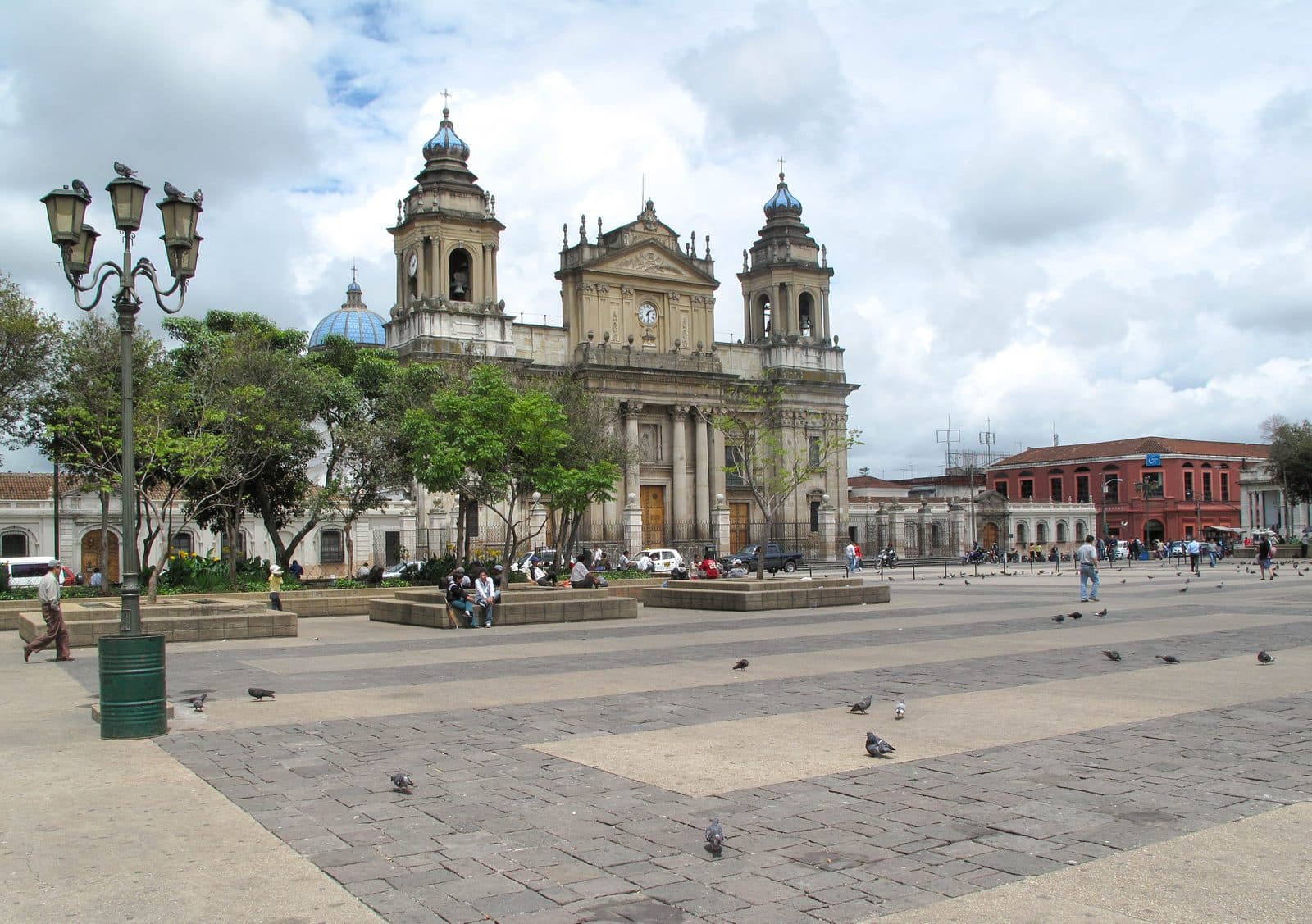
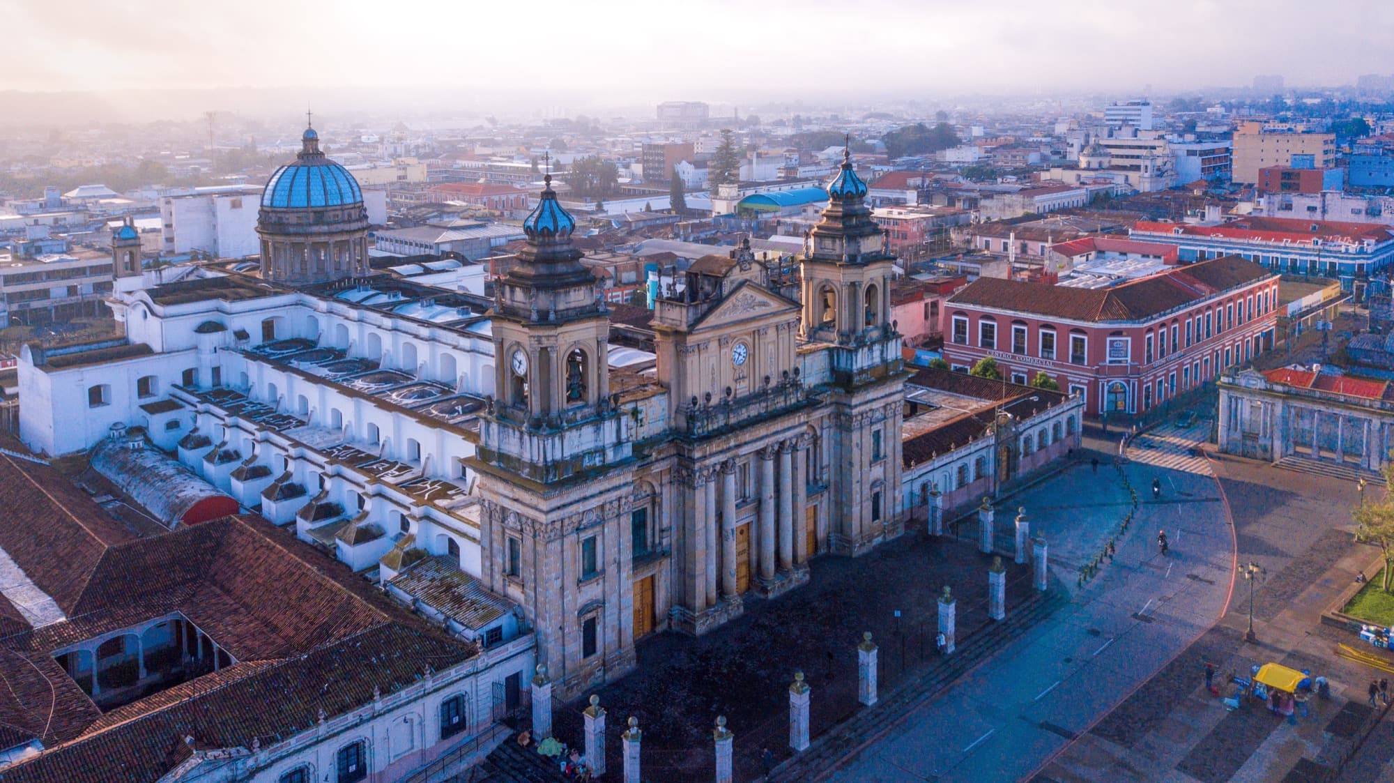
The colonial grid of 1776 still defines Zona 1. The Aycinena family's choice of the south side of the plaza for their mansions has shaped the social geography of that side ever since. The Catedral Metropolitana, on the east side of the plaza, was begun in 1782 and took eighty-five years to complete. The Palacio Nacional de la Cultura, on the north side, replaced an earlier government palace and was built between 1939 and 1943 by the dictator Jorge Ubico. The Mercado Central, behind the cathedral, was buried underground in the 1976 reconstruction so that the parking lot above it could remain civically respectable. Forty thousand people descend below the lot every day to buy food, clothing, and household goods at the market.
These four locations are the spine of the Who Rebuilt This City walking tour. Each of them tells a different story about who claimed Guatemala City's centre and what that claim cost the people who lived around them. The cathedral carries the names of the disappeared, gilded into the stone of the entrance pillars, where the families of people lost in the civil war (1960 to 1996) inscribed their dead in 2012. The Palacio holds the dictator's prison-built marble and the peace accord that ended thirty-six years of civil war: same building, same rooms. The market is the largest informal economy in the city, built and rebuilt by its vendors without state assistance. The plaza is where fifty thousand people forced Ubico's resignation in 1944. None of these histories are quiet.
If you walk Zona 1 cold, you will see streets that look ordinary. Some of them have been pedestrianised. The Sexta Avenida is a long, walkable promenade through what was, for a century, Guatemala's main shopping street. It is also the street where six hundred and eighty informal vendors were displaced in 2010 to make way for the pedestrianisation, by a mayor who had two years earlier signed the country's peace accords. Both things happened. The walk holds them next to each other.
Avenida de Las Américas: a hemisphere in bronze
South of Zona 1, in the wealthier southern zones, runs the city's second major historic axis. The Avenida de Las Américas was traced in the 1890s as an extension of the Avenida La Reforma, a Paris-inspired diagonal built by the Liberal president José María Reyna Barrios in the 1890s as a colonial ceremonial avenue. After Reyna Barrios was assassinated in 1898 the avenue went unfinished for decades. In 1948, the new democratic government of Juan José Arévalo renamed the southern continuation Avenida de Las Américas to mark the founding of the Organization of American States. In 1951, the formal programme to fill the boulevard with statues of national heroes from each country of the Americas was announced.
Three years later, that government was overthrown in a CIA-backed coup. The succeeding regimes, including military dictatorships, kept building the boulevard. Each successor added monuments. Each successor reinterpreted the meaning. Some monuments have been stolen for scrap metal. Others have been replaced. New ones have been added, including three slabs of the Berlin Wall installed at the southern end in the 1990s. The boulevard reads as a layer cake of competing claims to what hemispheric freedom means and to who has the standing to declare it. The Boulevard of the Americas walking tour treats it as an unfinished argument about freedom, which is exactly what it is.
The 1976 earthquake as urban event
You cannot understand Guatemala City without holding the 1976 earthquake in mind. The Motagua Fault released a magnitude 7.5 shock at three in the morning on February 4th. Twenty-three thousand people died. A quarter of a million were injured. More than a million were left homeless. The damage was geographically uneven in a way that earthquake engineers later named with regret: it killed along class lines. Adobe houses in the working-class neighbourhoods collapsed at much higher rates than reinforced-concrete buildings in the wealthier zones. The Guatemalan novelist Mario Roberto Morales called the event "the classquake." The phrase stuck.
Almost everything in Zona 1 was damaged. Several major buildings, including the Catedral Metropolitana, held because earlier engineers (the Italian Guido Albani's 1917 reinforced-concrete dome among them) had over-built for an earlier earthquake. The Mercado Central came down completely. It was rebuilt underground in 1983. The vendors who had been scattered for seven years returned to their stalls.
This is the texture of how the city remembers itself: not as a continuous history but as a series of resets, each one followed by a reconstruction whose authorship is contested.
How to walk it
The two anchor tours of the city are deliberately different in shape. Who Rebuilt This City is a tight loop through Zona 1, six stops in two and a half kilometres, oriented around a single question about institutional power. Boulevard of the Americas is a long linear walk down the southern axis, nineteen stops over three kilometres, oriented around a question about hemispheric freedom. Each can be walked in a morning. Together they give you a picture of the city that the airport-to-Antigua taxi window will not.
If you are coming to Guatemala on the standard route, which is most visitors, the city does not need to be the destination. But it should not be the place you skip. Spending a day on the ground in Zona 1 changes how you read the rest of the country: the Maya highlands you reach by bus, the colonial fabric of Antigua, the Pacific lowlands, the Petén. The capital is the negotiation between all of those Guatemalas. None of the other places can be understood without seeing how the negotiation has gone here.
What to read it as
A good frame for the city is this. Guatemala City is not a colonial city. The colonial capital was Antigua, and Antigua's buildings, sensibility, and slow pace are what most travel guides actually mean when they write about "colonial Guatemala." Guatemala City is the post-colonial capital, founded as a colonial replacement and grown across the entire arc of Central American independence, liberal reform, military dictatorship, civil war, and democratic transition. It does not present itself as quaint because it is not quaint. It is the building that all of modern Guatemala's politics have happened in.
The walls of that building hold the names of the disappeared and the signatures of dictators and the contributions of forty thousand vendors and the green cement of an authoritarian palace and the eternal flame of a democratic intention. The flame is out. The walls are still up. The argument is still going.
Walk the city for what it is, not for what the colonial cities of the region have trained you to expect. The reward is the most honest urban text Guatemala writes about itself.
Frequently asked questions
- How many self-guided walking tours are there in Guatemala City?
- Roamer currently has 2 self-guided audio walking tours in Guatemala City. Every tour is free to start: the introduction and first stop play in full, and every later stop plays a short preview before you decide to buy.
- How much does a self-guided walking tour in Guatemala City cost?
- Each tour is free to preview and $4.99 for lifetime access. If you want more than one, a 7-day pass is $12.99 and a 30-day pass covering every tour is $19.99, which works out to well under a dollar a day.
- Can I do the Guatemala City tours offline?
- Yes. Tours can be downloaded in advance in the Roamer app and played with no signal, which is useful when you are travelling without mobile data.
- How long are the Guatemala City walking tours?
- They run about 80 to 120 minutes, covering 2.5 to 3.5 km on foot, with up to 18 stops on the longest route. You set the pace and can pause any time.
Ready to experience it?
Historic Center: Who Rebuilt This City
75 min · 2.33 km · easy
More from Guatemala City
Explore more at your own pace.
Best Self-Guided Walking Tours in Guatemala City (2026)
Guatemala City Travel Guide: How Many Days, Getting Around, Is It Safe (2026)
One Day in Guatemala City: A Walkable Itinerary (2026)
Best History Walking Tours in Guatemala City (2026)
What to Eat in Guatemala City: A Food Guide (2026)